Most modern maps of the Peruvian Amazon only hint at the lives, indeed, the very existence of the people who live there. There are neat little dots representing the towns, and an occasional aeroplane icon to indicate where a pilot can safely land on an airstrip. Nature itself – a dense, verdant expanse of jungle – is shown in various shades of green, and if the map is a recent one, there will be shapes cut into those green areas denoting concessions to oil or logging and marking those areas waiting to be felled and exploited.
The blanket green and the empty spaces on the maps hide a cacophony of life because, aside from the rustle of its paper edges, a map can never sing as raucously as the jungle does. It does not resound with inhabitants’ voices as they travel along those blue lines that mark the river and its myriad tributaries, paddling their canoes to villages and hunting grounds, or the more ominous sound of large oil tankers as they too move along the Pastaza River – ominous because two-thirds of the Peruvian Amazon now falls under the shadow of potential oil drilling.
The Achuar of the Corrientes River, who live in the north-west of the Peruvian Amazon, already know the ecological footprint of the petroleum companies upon their land, leaving residues of oil-spills clogging the soil and polluting the rivers. This legacy does not show on the maps, but in the earth and water that people depend upon.
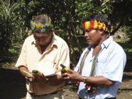
All that is about to change because, for the last three years, the Achuar people, along with another eighty-odd Amazonian communities, have been systematically mapping their lands in a project that, to date, has covered around a million hectares of Amazon forest. And it is this map – one forged from both the ancient wisdom of the elders and by using the most up-to-date Global Positioning System (GPS) mapping techniques – that Indigenous people will use to fill the blanks in existing maps.
“The mapping process is about empowering the Achuar people to communicate with the government and petrol companies to show where they live and why the forest is important to them,” explains Gregor MacLennan, co-founder of Shinai, a Peru-based NGO which introduced the mapping technologies and training to the Indigenous peoples. “The maps are drawn by the community in a two-day workshop and then community members walk to all corners of their territory with a GPS, geo-referencing everything that has been drawn on the map. We trained local people to both facilitate these workshops and to use GPS.”
The result is a map where hand-drawn symbols mark places of hunting and spiritual importance and provide a new description of the land. This is a living map that shows the seasonal changes in the forest, where the animals migrate, established hunting grounds, where medicinal plants grow and fish may be caught. It also shows where the spirits reside and areas where visions can be sought. The Achuar of the Pastaza hope too that it will serve to demarcate a boundary beyond which the petroleum companies cannot step.
Within the communities already affected by oil operations, Shinai has also trained environmental monitors to use GPS and digital cameras to plot and record any damage that is done by oil spills and pollution. Nantip, an Achuar elder, is categorical about what they are defending: “We collect many different resources from the jungle in order to feed our children and our grandchildren. We fish in the rivers and we wash and bathe in the crystal-clear waters of the springs and streams. Our ancestors lived here and depended upon the same resources and the same land. They cared for it well and left it, like a sanctuary, for us today. That is why we are alive and have life.”
The Achuar’s hope is that their hi-tech Living Maps prove that in this wilderness, under the density of the green canopy, the Amazon is an interconnected community where life is abundant and flourishing. It is not, as shown on other maps, an empty space. It is full of the calls of the forest, of the people and the animals that live there. These have a value, they have names and they have importance. Above all else, the Achuar Living Map is a land redrawn, not according to its potential resource wealth, but according to its real value to the people who live upon it.